The African Union has supported growing requests to stop using the Mercator map, which distorts the actual geographic size of Africa.
By asking states and international organizations to adopt more realistic estimates that reflect Africa’s true size, the African Union has thrown its weight behind an expanding campaign to stop the use of the Mercator map from the 16th century.
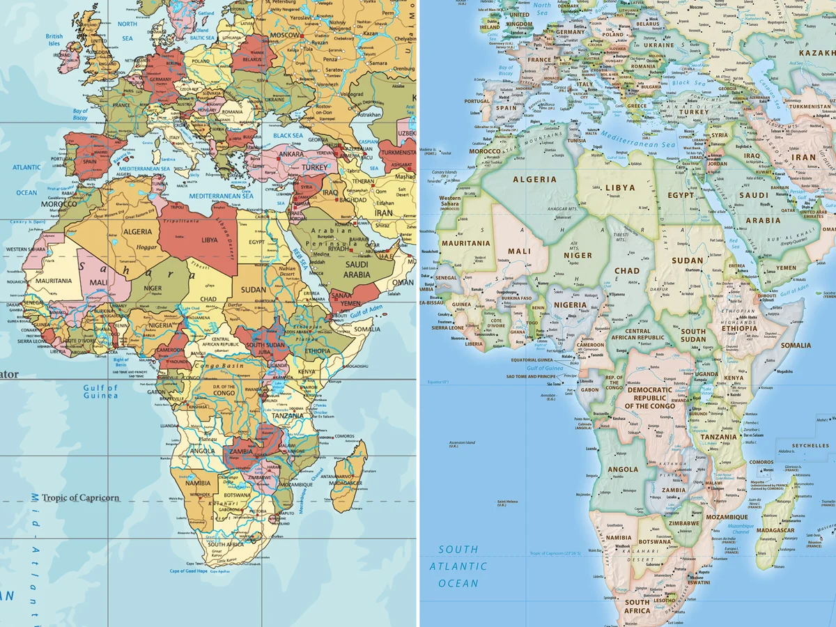
Inflating areas close to the poles, including North America and Greenland, and decreasing the size of Africa and South America, the map, which was first created by cartographer Gerardus Mercator for navigational purposes, drastically alters the scale of continents.
According to Selma Malika Haddadi, deputy chair of the African Union Commission, the map gave the continent a false sense of its significance, she told reporters. Haddadi said, “It may appear to be just a map, but it is not.” Despite having more than a billion people and being the second-largest continent in the world, she continued, the Mercator projection made Africa appear “marginal.”
Haddadi maintained that these depictions had a lasting impact on international media, education, and policymaking. As demands for reparations for slavery and colonialism grow, she affirmed that the AU’s 55 member states would work to find solutions that more fairly portray Africa and support the organization’s goal of “reclaiming Africa’s rightful place on the global stage.”
Advocacy organizations Africa No Filter and Speak Up Africa spearheaded the Correct the Map campaign, which promotes the Equal Earth projection developed in 2018, rekindling the controversy. The goal of the projection is to rectify centuries of geographic distortion and represent the actual sizes of nations.
Africa No Filter’s executive director, Moky Makura, stated that the continent’s map is now too small. The world’s longest campaign of deceit and misinformation must end.
The Mercator map harms Africans’ sense of identity and pride, Fara Ndiaye, co-founder of Speak Up Africa, said, particularly for young students who are first exposed to it in the classroom.
In all [African] classrooms, the Equal Earth projection will serve as the primary standard, according to a curriculum that we are actively working to promote, Ndiaye said. She wished for its adoption by international organizations, notably those in Africa.
The movement also calls for the replacement of the Mercator projection by international organizations like the World Bank and the United Nations. According to a World Bank representative, the organization was gradually removing Mercator from its online platforms and already had static maps using the Winkel tripel or Equal Earth projections. It also stated that it has made an official request to UN-GGIM, the UN geospatial agency.
A UN official stated that the idea would be reviewed and approved by an expert group.
Other areas have come together to back the AU’s position. According to Dorbrene O’Marde, vice-chair of the Caribbean Community Reparations Commission, the Equal Earth projection rejects the “ideology of power and dominance” seen in the Mercator map.
In 2018, Google Maps switched from Mercator to a 3D globe view on its desktop platform, while the mobile app still uses the old projection by default. Campaigners maintain that Africa and other southern continents will continue to be unfairly devalued in the world’s imagination unless the Equal Earth projection is adopted as the norm.