 "Where Africa Comes to Stay Informed."
US Edition
Thursday, August 27, 2026
"Where Africa Comes to Stay Informed."
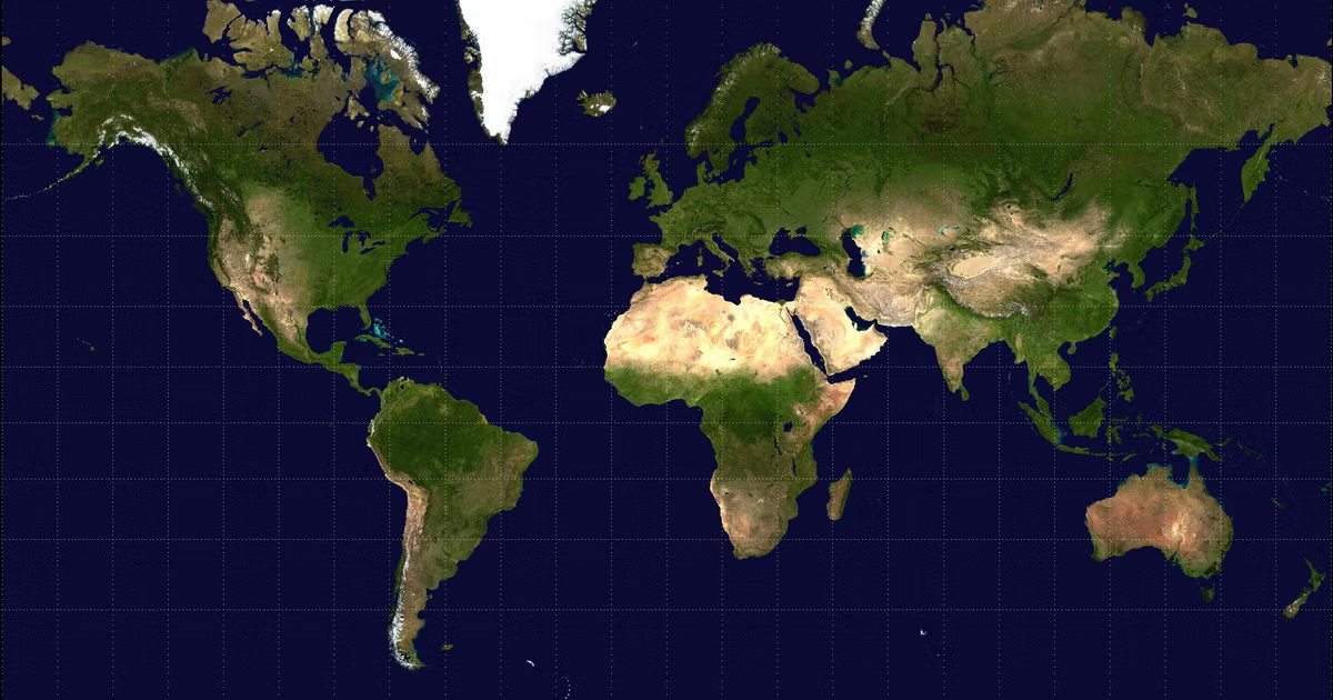
The UN General Assembly has voted to adopt a new world map that more accurately represents the true size of Africa.
The United Nations General Assembly has voted to replace the traditional Mercator world map with a projection that more accurately represents the size of Africa.
The “Correct the Map” resolution, sponsored by Togo and supported by members of the African Union, garnered the backing of 164 countries, including France and the United Kingdom.
The United States stood alone in voting against the resolution, with six countries choosing to abstain.
Even though the resolution lacks binding authority, observers expect the vote to impact the maps that institutions use globally.
The Mercator projection, in use since the 16th century, has encountered criticism for considerably distorting the relative sizes of continents and countries.
The map presents Africa as being approximately similar in size to Greenland, even though Africa is actually around 14 times larger.
Critics contend that these distortions play a role in shaping perceptions that downplay the scale, resources, and potential of equatorial countries.
The Mercator map was created in 1569 by the Flemish cartographer Gerardus Mercator to aid European explorers in their navigation efforts.
The distortion arises from the challenge of accurately depicting the Earth's curved surface on a two-dimensional map.
Countries situated nearer to the equator seem smaller, whereas those located closer to the poles appear disproportionately larger.
In 2018, a group of cartographers created the Equal Earth projection as an alternative that more accurately preserves the relative areas of continents.
In February, the African Union’s 54 member states embraced the projection, stating it “more accurately represents the sizes of all continents, particularly Africa.”
Online campaign group #CorrectTheMap stated, "You could fit the United States, China, India, Japan, Mexico, and much of Europe into Africa and still have land to spare.”
Ahead of Friday’s vote, Togolese Foreign Minister Robert Dussey expressed to Reuters, “A fair world begins with a fair map.”
During a UN briefing, Dussey remarked, “A map is never neutral.” It molds perceptions and affects the understanding of the roles of peoples and continents in the world.
He received support from French Foreign Minister Jean-Noël Barrot, who stated that France would cease using the Mercator map.
“Altering the map clearly does not alter the world.” “However, he stated that rectifying a misrepresentation of the world is, in itself, an act of truth.”
Yaryna Ferencevych, a US representative at the UN, expressed criticism of the resolution, stating that it undermined the work and purpose of the General Assembly.
“Rather than addressing the real issues of international peace, prosperity, or fostering good relations, this body is engaged in discussions about 16th-century map projects and their significance in promoting reparations and ‘cognitive justice,'" she stated.
The US also criticized a resolution adopted in March that declared the transatlantic slave trade “the gravest crime against humanity.”
Lerato Mogoatlhe from Africa No Filter, one of the groups behind the campaign against the Mercator map, told the BBC, "Africa's misrepresentation on world maps is not just a cartographic error—it's a narrative issue.”
She stated that the campaign was a component of efforts to halt what she referred to as the “world’s longest misinformation and disinformation” regarding Africa.
Kenyan geographer Kioko Muendo stated that the Mercator projection has subtly minimized Africa’s extensive resources, population, and investment potential.
“Maps serve as more than mere navigational tools for travelers—they influence the political and economic perceptions of regions,” he stated to the BBC.
Comments
0